New York and New Jersey declare emergencies as snow and ice hit the region
Photo credit: Andre Benz/Unsplash.com
Snow, sleet, and freezing rain have turned the New York and New Jersey region into a maze of slick roads, grounded flights, and emergency declarations that touch nearly every part of daily life. You are navigating a storm that is less about picturesque flakes and more about the hard math of inches, ice accretion, and the cascading disruptions that follow when two of the country’s busiest states slow down at once.
As you weigh whether to commute, travel, or simply step outside, the decisions made by governors, transit agencies, and forecasters are shaping what is possible and what is safe. Understanding how this winter system evolved, why both states moved into emergency footing, and what the data says about snow, ice, and black ice risk gives you a clearer sense of how to move through the next few days with fewer surprises.
The storm that reset winter in the New York City area
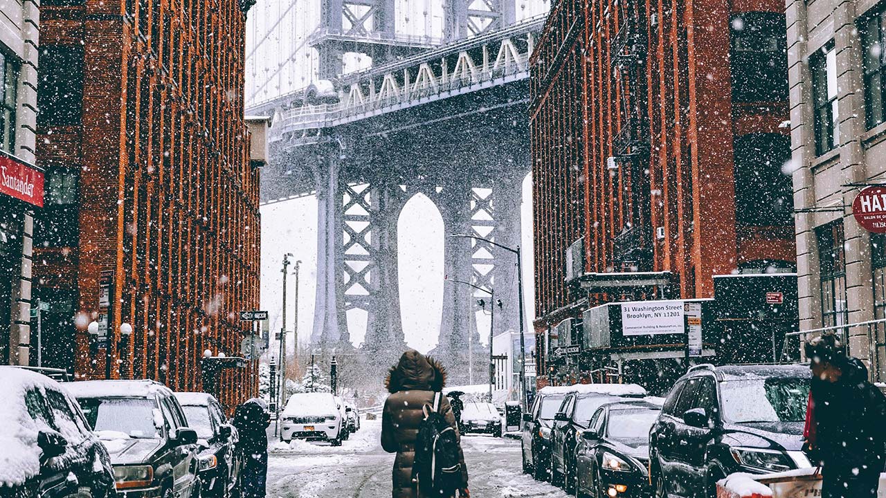
You are experiencing a winter system that has finally delivered the kind of snow and ice that had largely stayed north and west of the city in recent years. Forecasters warned that a broad Winter storm would pummel New York, New Jersey, and Connecticut, with snow bands pivoting across the metro area and a sharp transition zone where sleet and freezing rain would glaze surfaces. For you, that meant waking up to roads that looked merely wet but hid a treacherous layer of ice, especially in the outer boroughs and across North Jersey, where temperatures hovered around the freezing mark and a black ice warning stretched into Saturday night.
In New York City, the storm’s impact was measured not just in slippery sidewalks but in a notable snowfall benchmark. At the heart of Manhattan, Central Park recorded about 4 inches of accumulation, the highest total there since 2022, even though New York City and New Jersey ultimately saw less snow than some interior counties. That figure matters because it resets your expectations for what a “typical” winter looks like in the city, and it signals that the pattern has shifted toward more frequent, more disruptive events that can snarl commutes and test infrastructure even when totals stay in the single digits.
Why New Jersey moved first to declare an emergency
On the New Jersey side of the Hudson, state leaders treated this system as a serious threat long before the heaviest bands arrived at your doorstep. In TRENTON, officials framed the storm as a Severe Winter Storm, and the state’s leadership structure reflected that urgency. With the governor out of state, Acting Governor Way Declares State of Emergency Due to Severe Winter Storm, a move that unlocked resources for plow operations, utility coordination, and potential National Guard support. For you, that declaration is not symbolic; it is what allows crews to pre-position salt trucks, close vulnerable roadways, and prioritize life safety over routine traffic.
The legal footing for those decisions came into sharper focus when Acting Governor Tahesha Way, also in TRENTON, formally stated that Acting Governor Tahesha Way would place New Jersey under a State of Emergency effective at 1:00 p.m. as the core of the system approached. That timing matters for you if you live or work in New Jersey, because it gave employers and school districts a clear signal to dismiss early, reroute buses, or shift to remote operations before the worst of the snow and ice arrived. It also gave law enforcement the authority to restrict nonessential travel on key corridors if conditions deteriorated faster than expected.
New York’s sweeping emergency and the counties in the crosshairs
Across the river, New York took a broader, more geographically complex approach that you could feel from the city up through the Mohawk Valley. Governor Kathy Hochul’s office described how The State of Emergency impacts Albany, Bronx, Broome, Cayuga, and a long list of other counties as the storm’s snow shield and ice line shifted east. For you, that means the same system that coated the Bronx in heavy, wet snow was also dropping lake effect bursts on upstate highways and freezing rain on rural back roads, all under a single emergency umbrella that allowed the state to move plows and personnel where they were needed most.
If you live in one of those counties, the declaration is your cue that state-level assets are in play, from additional tow trucks on the Thruway to extra troopers patrolling secondary routes. It also signals that local leaders have a direct line into the state’s emergency operations center, which can coordinate shelter openings, warming centers, and hospital surge plans. By tying Albany, Bronx, Broome, Cayuga, and other communities into the same emergency framework, New York effectively told you that this was not a hyperlocal squall but a statewide winter storm that would move east throughout the day and into the night, with different hazards unfolding in different places as temperatures rose and fell.
Air travel meltdown: how the storm rippled through the skies
If you were planning to fly in or out of the region, the storm’s most immediate consequence was a wall of cancellations and delays that stretched far beyond LaGuardia and Newark. Reporting on the disruptions described how Nearly 15,000 flights canceled or delayed as both states declare weather emergencies after snowstorm, a figure that captures not just local misery but the way New York and New Jersey function as hubs for the entire national network. If you were stuck in Dallas, Atlanta, or Toronto, you were still feeling the knock-on effects of a storm centered on the Northeast.
Another analysis of the aviation chaos underscored that the problems were not confined to one day or one airport. As the system spread across the Northeast and into the Great Lakes, a Winter storm cancels more than 1,000 flights in the Northeast and Great Lakes regions as state of emergency declared in New York and New Jersey. For you as a traveler, those numbers translate into practical steps: building in longer layovers, downloading airline apps like Delta, United, or JetBlue to rebook from your phone, and considering Amtrak or intercity buses as backup options when airport operations grind to a halt.
From heavy snow to ice: what the forecast says comes next
Even as you dig out from the first round of accumulation, forecasters are already warning that the story is shifting from snow totals to ice risk. State officials have highlighted that a Winter Weather System Set to Bring Ice and Lake Effect Snow will keep New Yorkers on alert, with fresh bursts of snow downwind of the lakes and a renewed threat of freezing rain in the lower Hudson Valley and along the I‑95 corridor. For you, that means the snow you just shoveled could soon be capped by a crust of ice, making sidewalks and stoops even more hazardous and turning untreated side streets into rutted, frozen tracks.
Closer to the city, meteorologists are flagging a specific window when conditions could deteriorate quickly after dark. As one detailed outlook put it, Here is the latest forecast for the Tri-State Area on Sunday, By Matthew Villafane, Updated in the evening EST for CBS, and it points to a setup where surface temperatures linger near freezing while warmer air rides overhead, a classic recipe for freezing rain to develop. For you, that forecast is a prompt to finish errands early, move your car off exposed hills if possible, and keep a close eye on power lines and tree limbs that could sag under the combined weight of snow and ice.
Local alerts and advisories: how to read the fine print
Beyond statewide emergencies, the most practical guidance you receive often comes through county-level alerts that spell out exactly what to expect in your neighborhood. Regional meteorologists have issued a Winter Weather Advisory for All Counties in NY, Issued in the late afternoon EST and Expiring later that night in Dec, covering the South Shore, North Shore, and inland zones with slightly different timing. When you see that language on your phone or television, it is your cue that conditions will be disruptive but not necessarily catastrophic, with a focus on slippery travel, reduced visibility, and the potential for minor power outages.
For you, the key is to treat those advisories as actionable, not abstract. If your county is under a Winter Weather Advisory, you should plan for slower commutes, consider delaying nonessential trips, and give extra space to plows and emergency vehicles. The “All Counties” phrasing also tells you that this is not just a hill town or lake effect issue; it is a regionwide event that will touch city streets, suburban cul‑de‑sacs, and rural routes alike. Reading the fine print on start and end times, expected snow and ice amounts, and wind gusts helps you decide whether to switch to remote work, adjust school pickup plans, or reschedule deliveries that would otherwise put drivers on the road at the worst possible moment.
On the ground: how heavy snow and ice are reshaping daily routines
When you step outside, the storm’s impact is less about declarations and more about the crunch under your boots and the way your car handles the first turn out of the driveway. Video and field reports have captured how a Winter Storm has meant Heavy Snow Pounds New York, New Jersey, with Emergency Declared and Flights Affected across the region. For you, that translates into longer lines at gas stations as drivers top off tanks before potential outages, crowded supermarket aisles as neighbors stock up on shelf‑stable food, and a familiar choreography of shovels, snow blowers, and salt spreaders working in tandem on city blocks and cul‑de‑sacs.
Ice adds a more insidious layer to that picture. While you can see and measure snow, a thin glaze of freezing rain on steps, handrails, and crosswalks is harder to detect until you slip. That is why local officials keep emphasizing footwear with good traction, slow and deliberate walking, and the use of sand or pet‑safe ice melt on sidewalks. For you, it may also mean rethinking how you move around the city: choosing subway entrances with covered stairways, opting for buses instead of bikes or scooters, and giving yourself extra time to navigate platforms and intersections that can turn slick even after crews have treated them once.
Commuting, schools, and work: what the emergency means for your schedule
Once New York and New Jersey moved into emergency mode, the ripple effects on your daily schedule were immediate. Transit agencies adjusted service, with some commuter rail lines running on weekend or storm schedules and bus routes detouring around steep or flood‑prone streets. School districts weighed whether to close buildings, shift to remote learning, or call delayed openings, often aligning their decisions with the timing of the State of Emergency in New Jersey and the broader county coverage in New York. If you are a parent, that meant juggling childcare, work obligations, and the logistics of keeping kids occupied indoors while snow and ice piled up outside.
In New Jersey specifically, the timing of the declaration shaped how your Friday unfolded. New Jersey Acting Governor Tahesha Way declared the emergency effective at 1 p.m. Friday, a decision that gave employers a clear signal to send workers home early and allowed road crews to get a head start before temperatures dropped below freezing throughout the weekend. For you, that may have meant logging off early to beat the worst of the conditions, or, if your job requires you to be on site, navigating checkpoints and advisories that prioritized essential travel over routine errands.
Staying safe and prepared as the pattern stays active
Looking ahead, the pattern that produced this storm is not a one‑off; it is part of a broader stretch of active winter weather that will keep you on your toes. Regional briefings have stressed that New Yorkers should continue to monitor updates as the New York City and New Jersey corridor remains vulnerable to additional waves of snow, sleet, and freezing rain. For you, that means treating this storm as a dress rehearsal for the rest of the season: checking that flashlights and phone battery packs are charged, keeping a small emergency kit in your car with blankets and nonperishable snacks, and making sure you have a plan to check on older neighbors or relatives if power or heat are disrupted.
At the same time, state and local guidance is clear that your individual choices can either ease or compound the strain on emergency services. If you avoid unnecessary driving during peak icing, you reduce the risk of crashes that tie up first responders. If you clear your sidewalk promptly and safely, you help prevent falls that send people to already busy emergency rooms. By staying plugged into official channels, from statewide portals that describe how a Winter Weather System Set to Bring Ice and Lake Effect Snow will evolve to local alerts that refine the timing, you give yourself the best chance to move through this stretch of winter with fewer disruptions and a clearer sense of what each new advisory actually means for your life.


