Treacherous roads tonight as slush refreezes and black ice takes over
Slushy streets that felt merely messy during the day are hardening into something far more dangerous tonight, as temperatures fall and a thin, nearly invisible glaze of ice begins to spread. You are stepping into the most treacherous part of the storm cycle, when refreezing meltwater and leftover snowpack quietly turn familiar routes into traps. If you have to be on the road, you will need a plan, not just good intentions.
Why tonight’s refreeze is so dangerous
When snow tapers off, you tend to relax, but the real hazard often arrives a few hours later as slush and standing water cool back below freezing. That is when a transparent sheet forms over dark pavement, creating the classic conditions for black ice that can send your car sideways before you even realize traction is gone. The effect is amplified on bridges, overpasses, and shaded stretches, where air circulates above and below the surface and the temperature of the roadway drops faster than the air around it.
Forecasters repeatedly warn that this transition period, when wet roads quietly turn slick, is when you are most likely to overestimate how much grip your tires still have. In places like New Hampshire and other cold-weather states, that pattern is familiar: daytime thaw, nighttime freeze, and a spike in spinouts after dark. The same setup is playing out across wide swaths of the country tonight, as a fresh shot of Arctic air undercuts roads that were soaked by earlier snow and rain.
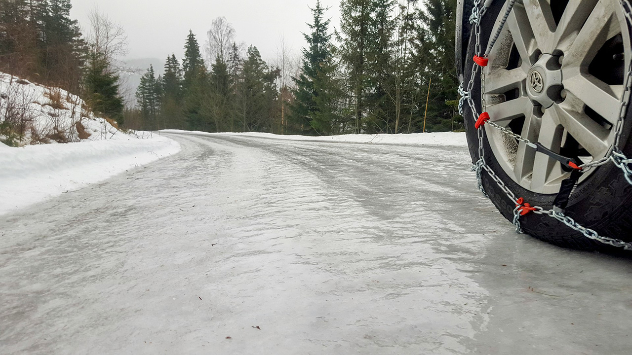
How black ice forms and why you rarely see it coming
Black ice is not black at all, which is what makes it so deceptive. It is a thin, clear layer that lets the dark asphalt show through, so to your eyes the road simply looks damp or slightly glossy. Legal and safety experts describe black ice as virtually invisible, forming when freezing rain hits a cold surface or when snow and slush melt, run across the pavement, and then re-freeze as temperatures drop again.
That process is exactly what you are dealing with tonight: earlier precipitation, followed by a sharp temperature fall that locks leftover moisture into a smooth, glassy film. Meteorologist Cruz A. Medina has explained that Black ice blends so well with dark surfaces that you often do not recognize it until your steering wheel suddenly feels light and unresponsive. National guidance reinforces that warning, noting that you should not let black ice sneak up on you because it can form quickly when wet roads meet subfreezing air and you might not even see it, a point stressed in winter-driving advice from Don’t-let-black-ice messaging.
Where conditions are deteriorating fastest
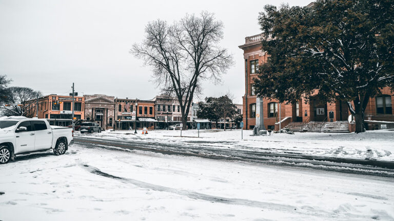
The risk is not confined to one region, and you should assume that any area that saw snow or rain earlier is now primed for a freeze. In the Upper Midwest, a FIRST ALERT TUESDAY EVENING highlights patchy blowing and drifting snow, including the snow that fell Sunday, with Patchy slick spots and temperatures dropping into the teens below zero by midnight. That combination across parts of Minnesota and neighboring states means any slush left on rural highways and city streets is turning into a sheet of ice.
Farther east, a fast-moving snowstorm recently dumped more than 8 inches of snow in many areas of New Jersey along and north of the I-95 corridor, with forecasters warning that black ice is possible as a dangerously cold night settles in after the flakes stop. Similar setups are unfolding in interior Pennsylvania and parts of Indiana, where daytime rain and wet snow are now giving way to plunging temperatures. In INDIANAPOLIS, for example, Winter is making a quick return after Sunday night storms, with forecasters warning that as temperatures plunge, winds will dry off roads quickly but leave stray ice patches that can catch you off guard on Indiana Monday morning.
Local alerts you should check before you drive
Before you even pick up your keys, you should be checking real-time alerts, because conditions can change block by block and hour by hour. The most reliable starting point is the national portal at The National Weather Service, where you can plug in your ZIP code and see if your route is under a winter weather advisory, a winter storm warning, or a dense fog advisory layered on top of freezing temperatures. In California’s Central Valley, for instance, the forecast for Fresno notes a Dense Fog Advisory that can reduce visibility to a few hundred feet, which is especially dangerous when you are also trying to spot ice on the road.
In the Upper Great Lakes, The National Weather Service issued a winter storm warning for Chippewa County, in effect from Tuesday afternoon until Wednesday evening, calling for up to 8 inches of snow and sharply reduced visibility. That kind of prolonged event means plows will be out, but it also means repeated cycles of compaction, melting under traffic, and refreezing after dark. In Northern California, a Winter storm watch for Northern California from Friday to Sunday warns of heavy snow and strong winds that can snap tree branches, and once that snow begins to melt at lower elevations, you will be dealing with the same overnight refreeze that is plaguing colder states.
Wind, visibility, and the hidden ice problem
Even when the pavement looks dry, wind and visibility can conspire to make hidden ice more dangerous. Strong gusts can blow snow back across plowed lanes, where it partially melts under traffic and then re-freezes into a thin, polished layer. In parts of Southern California, a wind advisory notes New guidance that Published December details WHAT to expect: Northeast winds 25 to 35 m with gusts up to 55 m, and WHEre drivers are urged to use extra caution. Those kinds of crosswinds can shove your vehicle sideways if your tires are already struggling for grip on a slick patch.
In the Plains and Upper Midwest, forecasters are also flagging patchy blowing and drifting snow that can obscure where the lane ends and the shoulder begins. That is especially problematic on rural highways in states like Minnesota, where open fields give wind plenty of room to pick up loose powder and drop it back onto the road. When that snow is ground into the surface by passing trucks, it can create a compacted, icy layer that looks like bare pavement from a distance but behaves more like a skating rink when you hit the brakes.
Real-world examples of how quickly roads can turn
Transportation officials have seen this pattern play out repeatedly, and their warnings are blunt. In Colorado, for example, a recent advisory told Motorists to take it slow and use extreme caution after the brunt of a snowstorm passed, because slick roads were likely even though the heaviest snow was already over. Officials emphasized that the main impacts would linger into the night and next morning, as compacted snow and slush froze solid while the air temperature dropped.
In the Midwest, a forecast from Latest News on Light snow and cold temperatures to ring in the new year, delivered by Meteorologist Caitlyn Lorr during a morning Weathercast, warned that even light accumulations can create a dangerous glaze when combined with falling temperatures. That is the same story in parts of Indiana, where earlier rain and a quick cold front left behind isolated slick spots that did not look threatening until drivers hit them at highway speed. These examples underline a simple point for you tonight: the absence of heavy snow does not mean the danger has passed.
Driving tactics that actually work on black ice
Once you are on the road, your best defense is to slow everything down. Legal safety guidance on winter crashes stresses that Black ice makes roads slippery, and driving too fast can cause you to lose control of your vehicle, so you should Slow down and increase your following distance. That means leaving at least five or six seconds between you and the car ahead, easing off the accelerator well before intersections, and avoiding sudden steering inputs that can break what little traction you have.
If you do feel your tires start to slide, the key is to stay calm and resist the urge to slam on the brakes. Anti-lock braking systems in modern cars like a 2024 Toyota RAV4 or a 2023 Ford F-150 can help, but they are not magic; they work best when you apply steady, firm pressure rather than a panicked stomp. National winter-driving campaigns from When recent rain or snowmelt meets freezing temperatures emphasize that you should steer gently in the direction you want to go, avoid cruise control on icy roads, and assume that shaded curves, ramps, and bridges will be slicker than the straightaways.
How to decide if your trip is worth the risk
On a night like this, the most effective safety move you can make is often to stay home. That is not always realistic, but you should treat every trip as a risk calculation: is this errand or visit important enough to justify driving on roads that may be hiding a transparent sheet of ice? If the answer is no, reschedule, switch to a video call, or delay until daylight, when road crews have had more time to treat trouble spots and the sun can help break up the glaze.
If you must go, stack the odds in your favor. Check the latest advisories from The National Weather Service, look at traffic maps for crash clusters, and scan social media feeds from your local transportation department for reports of spinouts or closures. In regions like New Hampshire, Pennsylvania, and Minnesota, where winter driving is a fact of life, seasoned locals often delay nonessential travel until plows and salt trucks have made multiple passes. You can borrow that same discipline tonight, wherever you live.
Preparing your car and your mindset for the overnight freeze
Even if you are not planning to drive until morning, you should treat tonight as your window to prepare. Top off your washer fluid, clear snow from around your tires so it does not freeze into a solid block, and park in a garage or under cover if you can to reduce the amount of ice that forms on your windshield. If you rely on navigation apps like Google Maps or Waze, remember that they can show congestion and crashes but cannot tell you where black ice is hiding, so you still need to drive by feel and caution, not just by the screen.
It also helps to adjust your mindset before you ever put the car in gear. Assume that every ramp, bridge, and side street has at least some slick spots, even if the main highway looks clear. In regions from Indiana to Chippewa County and up through snow-prone states like Minnesota, that assumption is what separates drivers who make it home without incident from those who end up in the ditch. Tonight, as slush refreezes and black ice takes over, the safest choice you can make is to treat every mile as a negotiation with the road, not a routine commute.