Lake-effect snow turns dangerous fast near Buffalo and forecasters warn it’s not over
Photo credit: Pavol Svantner/Unsplash.com
The latest Arctic blast has turned the Great Lakes and Northeast into a corridor of whiteouts, crashing waves, and failing power lines, leaving you to navigate both dangerous roads and dark, frigid homes. After a bomb cyclone ripped across the country, the new surge of polar air is tightening its grip, driving temperatures down and pushing utilities, first responders, and travelers to their limits. You are now living through a stretch of winter that tests not just your cold-weather gear, but the resilience of the region’s infrastructure and your own ability to adapt.
The storm that followed a bomb cyclone
You are not dealing with a single, isolated storm, but with a one-two punch that began when a bomb cyclone deepened rapidly over the central United States and then handed off its energy to a fresh system over the Great Lakes and Northeast. Meteorologists describe that earlier low as a classic case of explosive intensification, where pressure drops quickly and winds ramp up, setting the stage for the Arctic air that is now pouring across the region and feeding a new round of heavy snow and squalls. As that second system matures, it is dragging frigid air across the lakes, wringing out bands of snow that can bury one town while leaving the next almost untouched, a pattern that makes your planning and travel decisions far more complicated than a simple statewide forecast.
By the time the current winter storm descended on the Great Lakes and Northeast, thousands of customers were already without electricity from the bomb cyclone’s earlier damage, so the new round of high winds and snow is hitting a grid that was partly weakened before the first flake fell. Reporting from the region describes how the fresh storm is layering strong gusts, lake-effect snow, and bitter wind chills on top of that earlier event, turning what might have been a routine cold snap into a prolonged emergency for anyone living along the storm track. That compounding effect is why you are seeing power outages spread even as crews race to restore lines that were snapped or toppled during the initial bomb cyclone.
Arctic air, blustery winds, and dangerous cold
What you are feeling outside your front door is the leading edge of a deep Arctic air mass, dragged southward by the storm’s circulation and then locked in place by high pressure behind it. Temperatures are plunging well below freezing, and the combination of cold and wind is driving wind chills to levels that can cause frostbite on exposed skin in a matter of minutes, especially if you are stuck outside by a stalled car or a downed power line. Forecasters warn that the cold is not confined to the far north, with subfreezing readings spilling far to the south of the Great Lakes and into parts of the Mid-Atlantic, a reach that expands the number of people and systems exposed to the chill.
Blustery winds are doing more than just making it feel colder, they are turning every open stretch of highway and lakeshore into a hazard zone where snow is whipped into the air and visibility drops without warning. Those gusts are also the main reason tree limbs are snapping and power lines are swaying, which is how a winter storm that might otherwise be manageable becomes a widespread outage event that affects your heat, your water pumps, and your ability to communicate. Forecast discussions highlight how these Blustery winds are expected to persist even after the heaviest snow moves out, which means the risk of drifting, refreezing, and renewed line damage will linger into the days ahead.
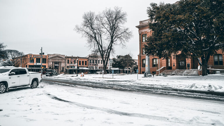
Snow squalls, whiteouts, and lake-effect bands
As you move through this storm, the most treacherous conditions may not come from steady, all-day snowfall, but from sudden snow squalls that behave more like warm-season thunderstorms than typical winter flurries. These narrow bands can drop visibility to near zero in seconds, coating pavement with a flash freeze of ice and snow that turns a routine drive into a chain-reaction crash scene before you have time to react. Forecasters have been issuing specialized alerts for these bursts, warning that the combination of intense snowfall rates and strong winds can be life-threatening if you are caught on an exposed highway or bridge.
Along the Great Lakes, the cold air sweeping over relatively warmer water is fueling classic lake-effect bands that can park over a single county and dump double-digit totals while nearby communities see only a dusting. That sharp gradient is why your neighbor a few miles away might be shoveling waist-high drifts while your yard shows only wind-scoured grass, and it is also why emergency managers are tailoring their warnings down to the level of individual corridors and towns. Coverage of the current system notes that the winter storm is expected to bring strong winds, heavy snow, and frigid temperatures to the Great Lakes and Northeast, with particular concern about fast-moving snow squalls that can catch drivers off guard.
Power outages spread from Michigan to the wider grid
If you are sitting in the dark right now, you are part of a much larger story playing out across the national grid as the Arctic blast stresses aging infrastructure. Nationwide, more than 127,000 customers were reported without power on Tuesday morning, a figure that underscores how a single winter system can ripple through multiple states and utilities at once. More than a third of those outages were in Michigan, where a combination of heavy, wet snow and high winds has repeatedly knocked lines down, forcing crews to work in dangerous conditions to restore service before the next wave of cold arrives.
Earlier tallies showed that Nationwide, nearly 74,000 customers were without power on Tuesday, which gives you a sense of how quickly the numbers can climb as new lines fail or fall under the weight of ice and snow. In Michigan alone, utilities have been racing to reconnect tens of thousands of homes even as fresh damage appears, a cycle that leaves some neighborhoods restored while others lose power for the first time. That dynamic is captured in reports that put the national outage count at 127,000 customers and also describe how nearly 74,000 were affected earlier in the week, a reminder that outage statistics are snapshots in a constantly shifting emergency.
Michigan’s hard-hit communities and the race to restore power
For you and your neighbors in Michigan, the numbers behind the outage map translate directly into cold bedrooms, shuttered businesses, and improvised charging stations in parking lots and community centers. About 60,000 electric customers regained power overnight in Michigan, a testament to how aggressively line crews have been working through snow and ice to restring wires and replace damaged poles. Even with that progress, thousands remain in the dark, and every new gust of wind threatens to undo some of that work by toppling freshly repaired lines or bringing down trees weakened by earlier storms.
More granular figures show just how concentrated the damage has been, with one snapshot listing Michigan 47,280 customers without power, New York 20,164, and Penn 16,961, a breakdown that helps you understand why some states are pleading for mutual aid crews while others are able to send help. Those tallies also highlight how the same storm system can have very different impacts depending on local tree cover, line maintenance, and whether ice or powdery snow is the main threat. As you watch utility trucks crawl through your neighborhood, you are seeing the front line of a restoration effort shaped by those metrics, including the 47,280 figure for Michigan and the surge of customers who were among the About 60,000 who saw their lights come back on overnight.
Travel chaos from Christmas through the New Year
If you tried to travel for Christmas or are now attempting to return home, you have felt how quickly winter weather can turn a routine trip into a logistical mess. Earlier in the holiday period, a separate winter storm dumped several inches of snow across the Great Lakes and Northeast, snarling post-Christmas travel and leaving drivers stranded on highways while airlines scrambled to de-ice planes and rebook passengers. That disruption set the tone for the days that followed, with backlogs of delayed flights and rescheduled train trips colliding with the new Arctic blast now sweeping across the same corridors.
As the latest storm settles in, you are seeing a repeat of those patterns, with state police urging drivers to stay off certain stretches of interstate and local officials warning that whiteout conditions can develop faster than plows can respond. For anyone who must be on the road, from nurses heading to hospitals to truck drivers hauling heating fuel, the combination of drifting snow, black ice, and sudden squalls is turning every mile into a calculated risk. The earlier post-Christmas system that left travel across the Great Lakes and Northeast in gridlock, described in reports that opened with the word Close, is now being followed by a second act that threatens to extend delays well into the New Year.
Scenes from the storm: from Alaska streets to Buffalo ice jams
Even if you are far from the storm’s bullseye, the images circulating from across the country give you a visceral sense of what this Arctic blast looks and feels like on the ground. In Juneau, Alaska, a car was photographed driving down a snowy main street in the downtown area on a Monday in late Dec, a reminder that the same cold air mass influencing your weather has roots in the far north where winter streets are often buried under fresh powder. That scene, captured in an AP Photo credited to Becky Bohr, shows headlights cutting through swirling flakes, a visual echo of what drivers from the Upper Peninsula to upstate New York are now experiencing as the storm spreads east.
Farther along the storm’s path, Videos on social media show people in Buffalo struggling to walk in the windy conditions as gusts push them sideways and send snow flying horizontally across sidewalks and intersections. One clip focuses on a waterway in downtown Buffalo clogged with ice chunks so thick that a local boater joked they could almost drive their boat over them, a striking example of how quickly waterways can seize up when Arctic air settles in. Those snapshots, from the Juneau street scene to the Videos from Buffalo, help you visualize the scale of the cold that is now gripping the Great Lakes and Northeast.
How local families and communities are coping
Behind the statistics and viral clips, you can see how individual families are improvising to stay safe and mobile as ice and snow take over their neighborhoods. In one upstate community, Chase Caruso and his father, Peter Caruso, were photographed spreading sand on their icy driveway during a freezing rainstorm, a small but telling example of how you might be turning to simple tools like shovels, sand, and rock salt to keep your own steps and walkways passable. Their effort, captured on a Monday morning in Dec, reflects the reality that for many households, the first line of defense against winter hazards is still manual labor and a watchful eye on the forecast.
Local governments are trying to support that work by issuing targeted Weather Alert messages that spell out which towns and counties face the highest risk of heavy snow, ice accretion, or flooding from windblown lake surge. Those alerts help you decide whether to send your kids to school, postpone a medical appointment, or check in on an older neighbor who may be reluctant to ask for help. The story of Chase Caruso and Peter Caruso, linked to a broader Weather Alert for northern portions of several counties, is a reminder that your own choices, from stocking up on supplies to clearing ice before it refreezes, can make a real difference in how you ride out the storm.
What you can do now as the Arctic blast lingers
As the Arctic air settles in for what could be several more days of dangerous cold, your most important task is to think in layers, both for your clothing and your planning. Dressing in multiple thin layers, covering exposed skin, and limiting time outdoors can reduce your risk of frostbite and hypothermia, especially if you lose power and have to rely on a car, a neighbor’s house, or a public warming center for heat. Inside your home, closing off unused rooms, using towels to block drafts under doors, and keeping faucets dripping slightly can help protect your pipes if the temperature inside begins to fall.
You should also treat travel as optional unless it is truly essential, because the same winds that are knocking out power are still capable of whipping up new squalls and drifting snow over previously cleared roads. If you must drive, keeping your gas tank at least half full, packing a winter kit with blankets, snacks, and a phone charger, and letting someone know your route can turn a breakdown from a life-threatening emergency into an inconvenience. Finally, staying tuned to local forecasts and outage maps, including updates that track figures like the Great Lakes and Northeast storm impacts and the evolving Winter pattern behind this Arctic blast, will help you make informed decisions as the region works to dig out, thaw out, and turn the lights back on.