The bomb-cyclone setup that makes this storm so disruptive
You are not imagining it: this winter storm feels different, faster, more punishing than the usual cold front that ruins a weekend. The reason is a classic bomb-cyclone setup, a combination of jet stream energy, ocean warmth, and surface temperature contrasts that turns an ordinary low into a rapidly deepening powerhouse. Understanding how that structure comes together helps you see why this system is so disruptive to power grids, travel plans, and basic daily routines across such a wide swath of the country.
Instead of a single hazard, you are dealing with a storm that stacks multiple threats on top of each other, from blizzard conditions and coastal flooding to dangerous wind chills and even severe thunderstorms on its warmer flank. When you know how those pieces fit, you can read the forecast with more precision, recognize when conditions are about to flip from manageable to life threatening, and make smarter choices about when to stay put and when to move.
What meteorologists mean by a “bomb cyclone”
When forecasters call a storm a bomb cyclone, they are not reaching for drama, they are describing a specific rate of intensification that turns a low pressure system into a meteorological bomb. In technical terms, bombogenesis occurs when a midlatitude cyclone’s central pressure drops by roughly 24 millibars in 24 hours, a sign that the atmosphere is pouring energy into the storm and tightening its pressure gradient. According to the U.S. National Oceanic and Atmospheric Administration, meteorologists use the term bombogenesis when a midlatitude cyclone rapidly intensifies, or strengthens, over a 24 hour period, and that rapid deepening is what unlocks the extreme winds and heavy precipitation that you feel on the ground.
In practice, you experience that definition as a storm that seems to flip a switch: winds ramp from breezy to damaging in a matter of hours, snow bands go from light to whiteout, and coastal water levels surge as the low deepens offshore. A recent Pacific system that forecasters flagged as a deep, intensifying bomb cyclone was expected to see an approximate 68 hPa reduction in pressure, more than double the usual bombogenesis threshold, which illustrates how explosive some of these setups can be when the ingredients line up over the ocean. That same report stressed that a bomb cyclone is different from a hurricane, but the rapid pressure fall and tight gradient can still produce hurricane force gusts and extreme precipitation rates that you have to treat with similar respect.
The atmospheric setup behind this week’s storm
The disruptive storm you are watching now did not appear out of nowhere, it grew out of a classic clash between Arctic air and subtropical moisture, organized by a sharp dip in the jet stream. Earlier in the week, forecasters highlighted how a very intense storm system would dig into the jet stream, allowing cold, dense air to plunge south while warm, moist air surged north ahead of the developing low. In a detailed briefing, meteorologists explained that this jet stream dip would help carve out a powerful upper level trough, priming the surface low to deepen rapidly as it tapped that contrast, a setup you could see in model animations shared in a widely viewed Dec forecast video.
As the low moved into that favorable environment, it began to strengthen quickly, transitioning from a sprawling but ordinary winter storm into a compact, tightly wound cyclone. The result for you is a storm that keeps evolving, with different regions cycling through rain, snow, ice, and wind as the system wraps up and moves east. Reporting on the current event has emphasized that the system rapidly intensified into what meteorologists call a bomb cyclone over the weekend, then continued to reorganize as it pushed across the Midwest and toward the East Coast, a progression that explains why conditions have felt so changeable from one day to the next.
Why this structure is so disruptive on the ground
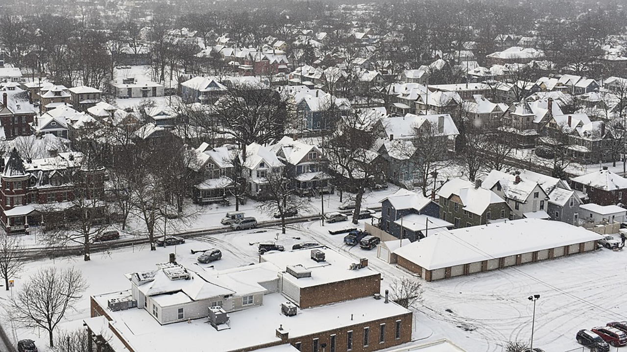
The same structure that excites meteorologists on satellite loops is exactly what makes your life harder on the ground. A rapidly deepening low creates a steep pressure gradient, which in turn drives stronger winds over a larger area, and those winds interact with heavy snow or rain to magnify impacts. When the current bomb cyclone swept across the northern United States, it brought blizzard conditions and whiteout visibility while powerful winds battered the Midwest and Great Lakes, a combination that turned routine highway trips into dangerous gambles and left drivers stranded in drifts that plows could not keep up with.
Those same winds are brutal on infrastructure, especially when they arrive on top of heavy, wet snow or ice that is already loading power lines and tree branches. As this storm evolved into a bomb cyclone and pushed east, hundreds of thousands of customers lost electricity, with one report citing 350000 homes without power as crews struggled to keep up with downed lines and blocked roads. Daylight has revealed the damage in community after community, from snapped utility poles to peeled roofing, underscoring how a single storm can disrupt everything from school schedules to hospital operations when its structure supports such intense, widespread gusts.
How the storm morphed into a nationwide travel crisis
For you as a traveler, the bomb cyclone’s most immediate impact has been the way it turned a busy holiday stretch into a logistical mess. As the low deepened and expanded, it created a sprawling shield of snow and high winds that intersected with major air and ground corridors, forcing airlines to cancel flights preemptively and highway agencies to close long stretches of interstate. Coverage of the current system has described how the storm escalated travel chaos as millions faced dangerous conditions, with airports from the Midwest to the Northeast dealing with cascading delays as crews tried to deice aircraft in subfreezing wind chills and visibility dropped below safe thresholds for takeoff and landing.
On the roads, the storm’s structure produced sharp gradients that caught some drivers off guard, with conditions shifting from wet pavement to glare ice and whiteout within a few exits. Reports from the central states described troopers responding to pileups where high profile vehicles were blown over and passenger cars slid into ditches as the bomb cyclone’s winds funneled across open stretches of highway. As the system pushed east, the same dynamic played out along new corridors, with one account noting that the powerful winter storm pushed east as cleanup began in the Midwest, leaving plow crews racing the clock to reopen routes before the next wave of snow and wind arrived.
Why forecasters saw this coming days in advance
One reason you heard the term bomb cyclone so early in the week is that the atmospheric signals were unusually clear, giving forecasters confidence to warn about rapid intensification well before the worst impacts hit. Numerical models locked onto the deepening trend as the storm’s energy crossed the Pacific, similar to a recent case where the energy that would kick off a bomb cyclone spent the weekend traversing the Bering Sea before diving into the West Coast. In that earlier event, meteorologists projected an approximate 68 hPa reduction in central pressure, a dramatic forecast that helped them flag the system as a high impact event even before it formed, and the current storm showed a comparable pattern of strengthening in model guidance.
By the time the low reached the central United States, private and public forecasters were aligned in warning that it would intensify into a bomb cyclone through Monday night, bringing blizzard conditions, damaging winds, and dangerous wind chills. AccuWeather meteorologists, for example, cautioned that the storm would deepen into a bomb cyclone through Monday night, with high winds expected to cause power outages and travel disruptions across large parts of the country. At the same time, the National Weather Service issued layered watches and warnings for snow, ice, wind, and coastal flooding, giving you a roadmap of when and where the storm’s structure would translate into the most hazardous conditions.
The role of ocean warmth and pressure falls offshore
Although you feel the storm over land, the most explosive deepening often happens over water, where relatively warm ocean surfaces feed energy into the atmosphere. When a cold, dry air mass sweeps off the continent and over a milder ocean, the temperature contrast between the surface and the upper atmosphere can be extreme, and that vertical gradient helps the low pressure center deepen quickly. In the Pacific case that forecasters highlighted earlier, the developing bomb cyclone offshore was expected to see an approximate 68 hPa reduction in central pressure as it tapped energy after crossing the Bering Sea, a reminder that the oceanic environment can double the usual bombogenesis criteria and supercharge the storm before it reaches you.
On the Atlantic side, a similar process is at work as the current storm moves off the East Coast and interacts with the Gulf Stream, a ribbon of warm water that can act like rocket fuel for midlatitude cyclones. As the low center tracks over that warm current, it can tighten its pressure gradient further, which is why coastal communities often see the strongest winds and heaviest precipitation after the storm has technically moved offshore. That offshore deepening is also what drives coastal flooding and beach erosion, as the bomb cyclone’s winds pile water toward the shore and its low pressure allows sea levels to rise, compounding the impact of high tide cycles on vulnerable barrier islands and harbors.
Stacked hazards: snow, wind, cold and severe weather
What makes this kind of storm so disruptive for you is not just one hazard, but the way several stack together in time and space. On the cold side of the low, deep wraparound moisture and strong lift create intense snow bands that can drop several inches per hour, while the tight pressure gradient produces winds strong enough to blow that snow into drifts taller than your car. In the current event, reports from the northern United States described blizzard conditions with whiteout visibility as powerful winds battered the Midwest and Great Lakes, a combination that made it nearly impossible for plows to keep roads clear or for emergency crews to reach stranded motorists.
On the warm side, the same dynamics can trigger severe thunderstorms and even tornadoes, especially where the bomb cyclone’s cold front plows into humid Gulf air. Earlier this season, people in Oklahoma were ordered to take cover now as a severe tornado warning was issued, and emergency officials stressed the importance of monitoring weather updates and local alerts to stay safe during ongoing severe weather activity. That kind of messaging applies directly to the current setup, because the storm’s structure supports a corridor of damaging straight line winds and rotating storms south of the snow zone, meaning you might be dealing with downed trees and power lines even if you never see a flake.
How emergency systems and utilities are adapting
For emergency managers and utility operators, a bomb cyclone is a stress test of planning, communication, and infrastructure resilience. The rapid onset of high impact conditions means they have to pre stage crews, equipment, and shelters before the worst weather arrives, often based on probabilistic forecasts rather than certainty. In Oklahoma, when a severe tornado warning prompted officials to tell people to take cover immediately, the emphasis was on real time alerts and the ability to push warnings quickly to phones, sirens, and broadcasters, a model that is increasingly used for winter storms when blizzard conditions or flash freezes are imminent and you have only a short window to act.
Utilities facing a storm like this one lean on similar principles, using forecast wind fields and ice accretion maps to decide where to position repair crews and how aggressively to trim vegetation ahead of the season. During the current bomb cyclone, power companies in the Midwest and Great Lakes had to contend with 350000 homes losing power as winds toppled trees and snapped lines, a scale of damage that required mutual aid from neighboring states and careful prioritization of critical facilities like hospitals and water treatment plants. As the storm pushed east and cleanup began in the Midwest, those same utilities shifted resources along the storm’s projected path, trying to shorten outages for you by having bucket trucks and lineworkers already staged near the next impact zone.
What you can do differently before the next bomb cyclone
Knowing how a bomb cyclone is structured gives you a practical edge when the next one shows up in the forecast. Instead of treating it as just another winter storm, you can look for the telltale signs of rapid deepening, like forecasters talking about pressure falls, jet stream dips, and explosive strengthening offshore, and adjust your plans accordingly. When meteorologists warn that a powerful storm will intensify into a bomb cyclone through Monday night, as they did with winter storm Ezra disrupting holiday travel across the United States, that is your cue to move travel earlier, stock up on essentials, and prepare for the possibility of extended power outages and blocked roads.
You can also make better use of the layered warning system that agencies and broadcasters rely on. Paying attention to winter storm watches, blizzard warnings, high wind alerts, and coastal flood advisories from trusted sources, then cross checking them with local emergency guidance, helps you avoid being caught in the most dangerous windows of the storm. When emergency officials stress the importance of monitoring weather updates and local alerts to stay informed and safe during ongoing severe weather activity, they are speaking directly to the kind of fast evolving conditions that a bomb cyclone creates, and your willingness to act on that information can be the difference between a close call and a crisis.